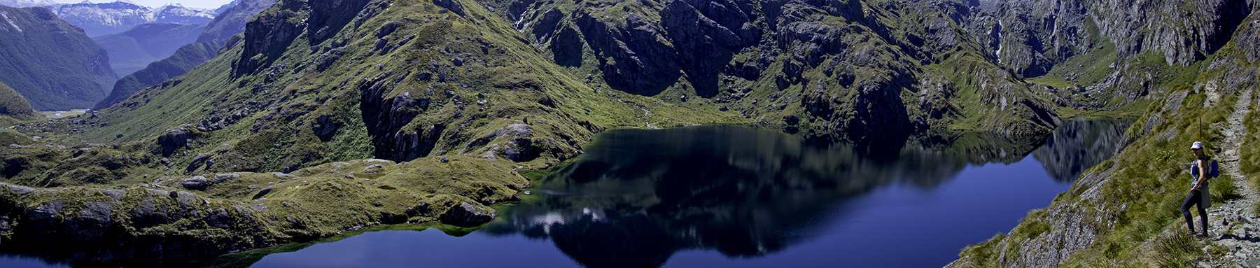
A couple of hours into a long run in the East Bay last Saturday, I crested a ridge and surveyed miles and miles of open space in all directions.
With three other runners, I was exploring the Ramage Peak Trail maintained by the East Bay Municipal Utility District (EBMUD). It lies in between Anthony Chabot Regional Park to the west and Las Trampas Regional Park to the northeast. More than once I said to myself, I can’t believe this is out here. I can’t believe it’s so big and so remote.
To the west, toward Oakland and the bay, multiple hills and ridge lines carved by oak-filled canyons blocked the site of the urban corridor along Interstate 580. To the east, toward the suburbs that sprawl along I-680 between Walnut Creek and Dublin, many more hills with ridges crowned by rocky outcroppings filled the view.
After gazing at this open space on a map for years, and looking down from an airplane and wanting to explore it, I finally found myself in the middle of this vast greenbelt of grazing land and protected watershed. I could scarcely believe I was right in the middle of the urban and suburban areas where I’ve been living and commuting for nearly two decades. I felt transported to another place entirely—to a Northern Californian countryside completely removed from development.

A sample of the views from the Ramage Peak Trail looking west, above the canyons surrounding the San Leandro Reservoir.
Many runners and hikers don’t know of or don’t use the treasure trove of East Bay trails maintained by EBMUD. I hesitated to write this post and spread the word, because part of what makes these trails special is the fact that you’ll encounter far fewer people on them than on the park district’s trails. But I can’t imagine they ever would be heavily used, because these trails take preparation and endurance.
Here’s what you need to know to run or hike on them:
- You absolutely must obtain a permit. Then you have to sign in at the kiosk of the trailhead with your permit number, and carry the permit in case you’re stopped by someone patrolling the area. One of the guys I was with said he hiked an EBMUD trail without a permit several years ago and was detained by an authority who treated him more like a criminal than a hiker. The water district understandably wants to guard against vandalism and contamination, so they keep tabs on anyone using the land. Good news: the permits are pretty easy to obtain through the EBMUD website page http://www.ebmud.com/recreation/trail-use-permit/east-bay-trails
- The EBMUD website also has two downloadable maps—one of the north watershed’s trails around Briones and San Pablo reservoirs, and one of the south showing those around the Upper San Leandro reservoir—but the maps are barely adequate to show you where to go. Several fire roads and other trails branch out from the main trails, so it’s relatively easy to get lost. But the fire roads loop around and connect, and the trail signage is pretty frequent, so you won’t get too lost. Have patience and carry a compass.
- Carry water—lots of it—and iodine purification tablets to treat water from streams or springs in case you run out. The trailheads and staging areas, for the most part, do not have drinking water. I carried 64 oz. in a hydration pack and two hand-held bottles, but I ran dry an hour before finishing and started to dehydrate.
- Be prepared for encounters with grazing cattle and, potentially, big cats. I wouldn’t recommend running solo out here due to the safety risk of animal encounters. Follow precautions detailed in an earlier post, “How to Run or Hike Safely.”
- No bikes allowed, period.
- No dogs allowed off leash; dogs allowed on leash only on a few of the shorter trails (Oursan, Hampton, and Kings Canyon Loop).
We started at the EBMUD’s southern-most trailhead, the Chabot Staging Area near the intersections of Redwood and Miller roads, just north of downtown Castro Valley. Our idea was to run Ramage Peak and Rocky Ridge trails, which sort of make two sides of triangle, all the way to Moraga, and then back—about 25 to 28 miles, depending on whether you add a portion of a loop. We wanted to reach the Rancho Laguna Park Staging Area because it has water.

The first stretch of Ramage Peak Trail.
So we set off at 7 a.m., the clouds in the sky pink from sunrise, and followed a trail that runs next to a Christmas tree farm. A little more than a mile in, we hit the first trail intersection and made a significant mistake, since the sign’s arrow was ambiguous. It seemed to point up toward the wider trail, so that’s where we went. But we should have kept straight and gone down the single track.

Oops -- this is the intersection where we took a wrong turn. We should have gone down that trail but instead headed up on the fire road. Pictured (L-R): Lance Fong, Jeff Pflueger and Tom Baudendistel
We ran a couple of miles on fire road and gained quite a bit of elevation before realizing we weren’t on the Ramage Peak trail. It wasn’t a bad mistake to make, since it rewarded us with a gorgeous view from a summit, but as we ran back down, we realized we were looping south back toward the parking lot. We worried we had sabotaged our long-run plan, and our map proved useless—we had no idea where we were.

This fire road is *not* part of the trail, but we had a good run up those hills ...

... and a great view from the top. (That's me with Jeff Pflueger.)
Fortunately, right after we resigned ourselves to running back toward the trailhead to retrace our steps and find the proper trail, we happened upon an intersection with the Ramage Peak Trail—a lovely, meandering single track. We figured we had gone off course nearly 2 miles—no biggie.

Thank goodness, we got back on the right track. This is the trail marker approx. 3 miles from the Chabot Staging Area.
For the next fives miles to its intersection with Rocky Ridge Trail, the Ramage Peak Trail covers an impressive diversity of terrain and landscape. Many portions followed a single track through canyons dense with oak and bay trees. Sometimes oak leaves crunched underfoot; at other times, long, slippery pieces of eucalyptus bark carpeted the trail. Higher up, green grass blanketed the barely discernible trail.

Taking a break after one of many uphill climbs along Ramage Peak Trail.
Our friend who was supposed to be our guide, who had run this before, had canceled at the last minute, but he left word that we were supposed to look for an oak tree on a ridge line on a summit, and that’s how we’d know where to go. This seemed absurd as I gazed at many ridge tops with numerous oaks. Which tree was he talking about? But, sure enough, the trail climbed switchbacks out of a canyon to a summit where a distinctive oak stood anchored in a natural monument of rock. A lone white plastic ribbon hung from its branch, a subtle trail marking. This may have been the summit of Ramage Peak, but I’m not sure—we reached so many peaks, I don’t know which was the trail’s namesake.

This is *the* tree at the summit you want to find. The trail drops sharply into another canyon on the other side.
At the intersection with Rocky Ridge Trail, we abandoned our original plan to run all the way to Rancho Laguna Park in the interest of time (and wrongly thinking we had enough water). We instead chose to do the Rocky Ridge Loop before heading back on Ramage Peak Trail. The three-mile loop addition definitely is worth doing—but extremely steep. “Good Ohlone training,” we all agreed, a reference to the Ohlone 50K, and indeed those uphills mimic the Ohlone course in the Sunol wilderness to the south.

Rocky Ridge as seen near the intersection with the Ramage Peak Trail. The Rocky Ridge Loop Trail goes around and behind it.
The Rocky Ridge Loop hits the border of Las Trampas Regional Park, and we looked down to glimpse Bollinger Canyon Road, an artery to the suburbs.

At the border between EBMUD land and Las Trampas, we could see Bollinger Canyon Road down below and Mount Diablo in the distance.

Another view of Rocky Ridge, looking northwest toward Oakland.

Jeff and Lance run the ridge at the edge of Las Trampas Regional Park, approaching the radio tower before a long descent on Rocky Ridge Loop Trail.
After the loop, we headed back on the Ramage Peak Trail, running at a steady pace but hiking a lot of the uphills. We spooked flocks of wild turkey and pheasant but otherwise didn’t see wildlife, although the skeletal remains of some medium-size animal on the trail indicated that more game and prey call the place home.

Heading back through the canyons and oak-bay woodlands of Ramage Peak Trail.
We got back to the car after about 5.5 hours, having covered about 23 miles—a slow pace, including breaks, but not too bad considering the elevation gain and loss. Jeff’s altimeter calculated about 6000 feet of up & down.

Me near Rocky Ridge midway through the run.
EBMUD maintains about 80 miles of trails through 27,000 acres of open space, and with this run/hike, I can say I’ve covered all but two major portions of the network (the Old San Pablo, Inspiration and De La Vega trails in the northern half).
Before, I had two favorite EBMUD trail runs: the Kings Canyon Loop/Redwood Trail in Moraga, and the Oursan/Bear Creak loop around Briones Reservoir near Orinda. Now, it’s Ramage Peak.
Two final thoughts:
Where does the name Ramage come from? I don’t know, but I’d like to find out.
And, why do I yearn to spend half the day virtually by myself, unplugged and removed from civilized life in this hiding-in-plain-sight open space? Same answer.
Pleased to read your adventure. I’ve been to that trail some years ago before I took on ultra/trail running. It was a hike from Cull Canyon after a walk from Castro Valley BART. I hiked Garin to Chabot trail (Mark Tanaka) to the start of the Skyline trail in Lake Chabot. After I turned to Ramage trail (didn’t know the name), it was like an unknown new world since it’s not on any maps I had. I spotted wild turkeys, a bog family with the fear of mountain lions attacking from behind. After arriving Las Trampas, I kept walking to a BART station, which was a long walk!!! Apparently, I was so beat up when getting home. I guess I’d like to run the route next time, but probably I’m afraid not with the struggling experience clear in mind.
Chihping, you rock!
Great article. The early trail junction has been missed by many over the last few years. Still, this time of year, without significant rain should have provided you with great trail running.
Now imagine this run during high wildflower season.
Sam
Yes, Sarah, you found one of my secret training grounds. The first time I tried to make the crossing, the grass was so high on that trail up the hill next to Ramage, I couldn’t figure out where to descend (poor signage as you noted). I ended up bushwhacking through poison oak before giving up and heading back to Castro Valley. There is also a trail in and out of Cull Canyon Park that leads to the Ramage Peak Trail, also very nice– single track more technical than than Ramage and then opens to a similar plateau with views of Trampas, Chabot, etc. Thanks for relieving me of the responsibility of blogging about this. I think the tour buses won’t be showing up and ruining the experience, otherwise I might be irritated. I actually enjoy seeing people out there.
Conincidentally and reciprocally I first hit the northern EBMUD trails connecting to Briones and Tilden a few months ago.
Here’s a funny one (regarding bringing enough water) when I used to run Ramage east and then get driven back by my wife when she still worked out in the 680 corridor:
Cull Canyon, Garin to Chabot, Ramage Peak, Devil’s Hole, Elderberry Trails
Thu, Sep 10, 2009 11:12 Pacific Time (US & Canada)
Time 4:36:31
Distance 18.48 miles
Avg Pace: 14:57 min/mi
Elevation Gain: 8,150 ft
Elevation Loss: 7,491 ft
11 days after Cascade Crest 100 Mile Endurance Run. feeling tired early. gear: Sportiva Crosslites, Black Diamond trekking poles, Ultimate Direction Wasp pack, filled it with 64 ounces of water at Columbia (split 2), probably not enough powdered Gu2O. 2 gels. fluids out at 3:40 climbing Devil’s Hole Trail. bonked. P picked me up and I was too dizzy to keep driving. Pink’s “Please Don’t Leave Me” ear worm, ugh.
Sarah, great write-up and wonderful timing too. About 1 month ago I ventured on a run from the Chabot shooting range to Hayward which traversed the Garin to Chabot trail through this area.
I was REALLY surprised to read that I needed a permit to run through. The problem was I was dropped off and couldn’t turn back, so I ran permit-less (glad I wasn’t caught based on your friend’s warnings).
That run opened up my map Googling into the more northern EBMUD trails… by just looking at the maps my jaw dropped. Then I read your blog post and Mark’s comments… and WOW.
Thanks Again.
It’s an amazing trail. When I did it last October, I met 2 (two!) people along the whole trail from Redwood Road all the way to the staging area at Las Trampas.
One caveat though, and nothing to do with animals, in one gorgeous canyon about ~5miles in, it smelled like pot for a half mile or so. I did not hang around and explore there but am willing to bet I was nearby a pot farm. Then a few weeks later, a cop was shot at in parkland a few miles away.
Thank you so much for sharing some of your favorite “secret” still unspoiled running spots. I am fairly new to the area and love discovering new trails, so I will check this area one day. And I like running in a “self sufficient” way, well, often, it just means carrying a heavy backpack. I also just discovered your blog and really enjoy reading, smiling, laughing, ouching, cheering, “sympathizing”, …
What a great adventure, running and capturing every happy moments is really amazing… I can’t wait this coming summer, I will spent my vacation like this.
I just ran this today, I Googled it and this page came up. Awesome work, thanks!
I just ran here this weekend and saw a bobcat, a coyote, 20+ turkeys, quails and 3 deer (and of course cows)
There is a terrific writeup of this hike in the book East Bay Trails by David Weintraub, pp. 109-113 (WIlderness Press, 2nd Ed. 2006 printing).
I hiked this route twice from Las Trampas to Redwood Rd, before attempting the reverse. Even with knowledge of the route, it was still confusing when starting from Redwood Rd.
Hello,
Thanks so much for the description.
We hiked from the Chabot Staging Area (right next to the Christmas tree farm) to Rancho Laguna Park in Moraga via Rampage Peak Trail, and Rocky Ridge. We encountered the same confusion towards the beginning with the ambiguous trail sign. To make matters worse, there are now 2 single tracks, one heading into a wooded creek area, and one running parallel to the big open field to the west of the trail. Take the one next to the field.
The highlight for me was finally making it to “the box.” If you look on google sat images, theres this strange box encircling a couple acres close to Miller Rd and the southernmost finger on the east side of San Leandro Reservoir. The trail passes by an old barn and house, but you might miss the turn off if you are running too fast. Turns out the box is a double row of eucalyptus tree demarcating the ridges around the barn/house, not alien crop circles.